--Overview of the deep map levels:
 |
Level One allows you to navigate the continent from coast to coast, and from southern Alaska to the northern Yucatan. Underlying the entire map, a click away, is the complete map set from John Swanton's Indian Tribes of North America, with tribal locations in 1640. Other time windows are available as well, on the Northern Plains and east of the Mississippi. |

|
Level Two is the first zoom-in level, as well as the entry point on the "Enter Deep Map" button at the left. This is the level for a more detailed view of the "big stories." Time windows for 1640, 1680, 1755 and 1885 are now available on the Northern Plains. 1755 covers the eastern half of the continent. Click a tribal name on the 1640 map and learn more. |
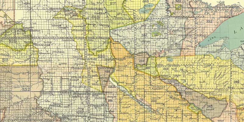 |
Lying under Level Two,
in the Upper Midwest, is the first section
of the Treaty Map. Several months of 2013 and 2014 have
been spent constructing a huge Cession map of the Continental U.
S., by combining more than 30 state and area maps from the
National Archives of the tracts ceded to the government by the
Native American Tribes prior to 1900. The smaller maps were
brought to a common scale and manipulated so they could be
gradually merged into a master map nearly 2 gigabytes in size, and
then sliced into panels to enable display in your browser. The
color-coded tracts have been annotated with the information about
the individual treaties and agreements contained in nearly 1,000
pages of Indian Land Cessions in the United States from the
Eighteenth Annual Report of the Bureau of American Ethnology,
published by the Government Printing Office in Washington, D. C.
in 1900. It can be reached from here, or from the Time Windows drop-downs in the appropriate geography of Levels One and Two. Click on the image at left to access the "Quick Start" to the "Treaty Map" materials Completion of the transfer of panels and annotation coding for the rest of the continent will be time consuming and expensive, but we will keep chipping away at the project, as resources allow.
|
|
|
|
Level Three zooms in to regions, based on a merged set of 1:250,000 scale USGS maps. It is gradually being expanded, as an environment for regional stories and a treaty history of the land. Each Northern Plains expansion includes a time window into the Joseph Nicollet's 1840 "Mother Map." | |
 |
Level Four provides a backdrop for the hidden history of counties, cities and towns. Nicollet's map is also available. The place names and other details are being translated from the Dakota, and video of the elders explaining them is now in final editing and digitization. |


|
Level
Five allows neighborhood stories to be placed into geographical
context. The area of coverage is presently limited to the
demonstration "deep core" around the riverbend in Saint
Paul. It will be expanded. Two time windows are available. |
|

|
Level Six helps users to target small areas and reach down to the story and memory environment in the windows into the hidden history at Level Seven. There are very exciting plans for enriching this level with street identification and other features. | |

|
Level Seven is the the heart of the deep map. Our dream is that, as images and stories accumulate on the blocks and street corners, it will be possible to taste life in the decades of the past. These time windows cover the area where the Grand Excursion landed in 1854, and where the flotilla will dock in July, 2004 |
---You may find yourself using the "BACK" BUTTON on your browser more than your usual custom. (At least we do.)
---![]()
![]()
![]()
![]() ---Arrows at the edges
of map coverage can be used to navigate within the areas available. As you mouse over a map, a change to a pointing cursor
will you tell you that a zoom-in is available, or that there is further
information imbedded in the map.
---Arrows at the edges
of map coverage can be used to navigate within the areas available. As you mouse over a map, a change to a pointing cursor
will you tell you that a zoom-in is available, or that there is further
information imbedded in the map.
---Hints and tips will appear in the Notes Panel to the left. And don't miss the "zoom out" and "Time Windows" buttons at the top of the maps.
---For the answers to common questions, please use the "Tell Me More" button on the Home Page.
---Please bear with us as we fill in the blanks and bring new historic maps and increasing detail on line. As these "where and when" paths open, we will also be adding information about what was (and is) happening at those times and places. The project is seeking funds for this work and to open the where/when "quilt frame" to "squares" created by others in during 2014 and 2015.