 |
The
"Deep Map" This is the centerpiece of the on-line Archive Project. It is an information environment for the hidden and neglected history of the the Northern Plains (and continent), using a where/when interface to the stories of everyday heroes and lost places. Click the image to learn more about all seven levels, from continental views to the riverfront and West Side Flats in Saint Paul. |

|
The Working River The Mississippi looks a lot different from the deck of a towboat. We're working on digitization and streaming of video to prove it. There is also material about the ancient trading place now called Harriet Island and Archive Project support to its rededication as a regional park. AND the first towboat competition in years...this you have to see! |
 |
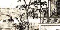
The Riverfront
During the months leading up to the Grand Excursion, we will be enriching the historic maps in the "time windows" along the Saint Paul riverfront, Harriet Island and the West Side Flats where the events will be taking place in 2004. Registered maps from 1851, 1867 and the present are now available and enrichment with popups and features is underway. Soon....1916 and 1874. Click the map to jump right to Level Seven of the Deep Map. |

|
The "Sundries
Department" Ok, it's really more of a discussion than a market, but we do offer an expanding selection of books, recordings and (soon) images relating to the viewpoint and heritage of folks in the mid-continent watersheds. The bookshelves feature the complete works of Jack Weatherford and other hard to find titles. The record shelves feature John Stewart's whole catalogue as well as early blues and (soon) jazz. |
 |
Opening page Click the 1867 image at left to explore the complete range of Northern Plains Archive web site possibilities. Check out the Honor Wall, drill down through all the levels of the Deep Map to the riverfront where the Grand Excursion 2004 riverboats will land and much more. |